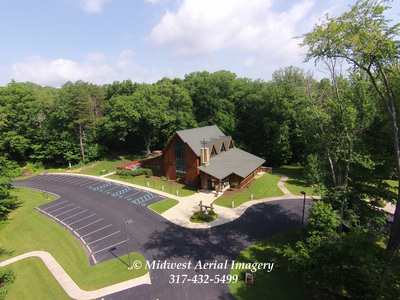
High Definition Aerial Photos, Video, 3D Mapping
FAA Certified For Commercial Use
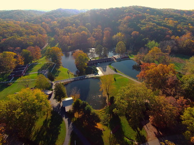
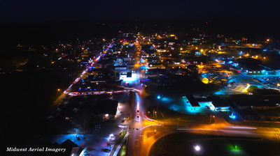
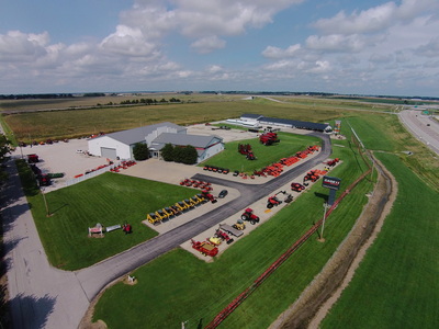
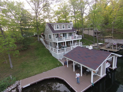
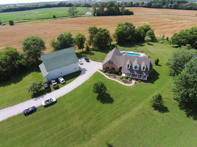
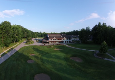
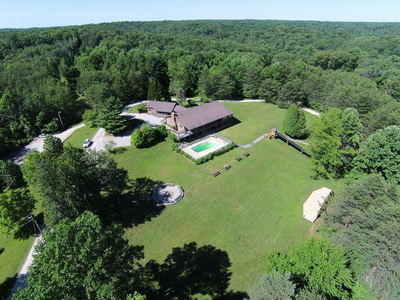
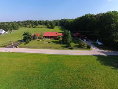
We use radio controlled stabilized aerial camera platforms for real estate, construction projects, inspections, hard to reach structural damage assessment, agricultural, 3D surveying/mapping, weddings, business promos and more...
Midwest Aerial Imagery provides aerial photos, stand alone video, or full video productions (aerial and ground) using stabilized high definition aerial cameras to capture the essence of your property or project. You can stand right next to us on the ground to see live what the aerial photo or video will look like and we can download it to your computer immediately after the flight. You can then use it on your website, Facebook, etc. or get a large copy printed out at your local drugstore or other location.
Whether it be for your personal property or business we can present your property or project in economical, creative ways previously unavailable.
Pricing begins at less than $100.
Contact us at 317-432-5499 to discuss your particular needs.
Click on a photo below to enlarge it.
Interactive 3D Mapping of Your Construction Project, Home, or?
For a link to a 3D Interactive model created with DroneDeploy software autonomously flying the drone, click the link below:
Open it and double click on it to rotate around that point.
Left click and drag to rotate around.
Right click and drag to move left, right, up, down.
Use your mouse wheel to zoom in and out.
https://sketchfab.com/models/31fbfe39c2a24d2cbc3e7bc4086ec619
PanoramaStudioViewerParams = {
"panoramaStudioViewer": {
"actions": [
{
"func": "function(){ var enabled = this.viewer.gyroscopeEnabled(); var gb = this.get('gyrobutton'); if (gb){ gb.skin = enabled?gb.enabledskin:gb.disabledskin; gb.updateSkins(); } }",
"id": "updateGyroButton"
},
{
"func": "function(){ if (!this.viewer.fullEquirectangular()) return; this.viewer.panTo(this.viewer.getView().pan,0,100,1.0,0,'easeInOutSine',true); this.tween({'time': 1.0, 'lp': 0.0, 'transition': 'easeInOutSine', 'onInit' : function(a,dstParams){ a.lp=a.viewer.fisheyeDistortion(); }, 'onUpdate': function(a){ a.viewer.setFisheyeDistortion(a.lp);}}); }",
"id": "leaveLittlePlanet"
},
{
"func": "function(){ if (!this.viewer.fullEquirectangular()) return; this.viewer.panTo(this.viewer.getView().pan+90,90,150,1.0,0,'easeInOutSine',true); this.tween({'time': 1.0, 'lp': 1.0, 'transition': 'easeInOutSine', 'onInit' : function(a,dstParams){ a.lp=a.viewer.fisheyeDistortion(); }, 'onUpdate': function(a){ a.viewer.setFisheyeDistortion(a.lp);}}); }",
"id": "enterLittlePlanet"
},
{
"func": "function(a){ var id = this.viewer.currentMBId; if (!!id&&(a.id!=id)){this.viewer.action('hideMessage');} if (a.id!=id){ var s=this.viewer.get('globalData'); if (s&&s.messageBoxStyle){ a.style = s.messageBoxStyle; }this.viewer.currentMBId=null; if (!this.viewer.isVRModeEnabled()){ this.viewer.add('textbox',a); this.viewer.currentMBId=a.id; } } }",
"id": "showMessage"
},
{
"func": "function(){ if (this.viewer.currentMBId) this.viewer.remove(this.viewer.currentMBId); this.viewer.currentMBId=null; }",
"id": "hideMessage"
},
{
"func": "function(a){ var id = this.viewer.currentMBId; if (a.id!=id){ this.viewer.action('showMessage',a); } else { this.viewer.action('hideMessage'); } }",
"id": "toggleMessage"
}
],
"button": [
{
"align": "leftbottom",
"height": 24,
"id": "showTbButton",
"onclick": "function(){ if (!this.allowClick) return; this.allowClick = false; var tb = this.get('toolbar'); tb.setVisible(true); tb.style = 'transform-origin: 50% 100% 0px; transform: translate(0px,0px) translateZ(10000px) perspective( 800px ) rotateX( 0deg ); background: rgba(0,0,0,0.5); transition: transform 500ms;'; tb.updateStyles(); this.tween({ 'delay': 0.5, 'time' : 0.01, 'onComplete' : function(a){ a.setVisible(false); a.get('hideTbButton').allowClick = true; } }); this.style = 'transform-origin: 50% 100% 0px; transform: translate(0px,0px) translateZ(10000px) perspective( 800px ) rotateX( 90deg ); transition: transform 500ms;'; this.updateStyles(); }",
"oninit": "function(){ this.setVisible(false); this.allowClick = false; }",
"skin": "shadow(4,0,0,rgba(0,0,0,1));shadow(3,0,0,rgba(0,0,0,1));comp(1.0);copy(defaultSkin,128,192,64,64,0,0,24,24)",
"style": "transform-origin: 50% 100% 0px; transform: translate(0px,0px) translateZ(10000px) perspective(800px) rotateX(90deg); transition: transform 500ms; ",
"styleactive": " background-color:rgba(255, 255, 255, 0.25); box-shadow: 0px 0px 9px 8px rgba(255, 255, 255, 0.25); ",
"stylehover": " background-color:rgba(255, 255, 255, 0.15); box-shadow: 0px 0px 9px 8px rgba(255, 255, 255, 0.15); ",
"width": 24,
"xoff": 0,
"yoff": 0
}
],
"buttonBox": [
{
"align": "bottom",
"button": [
{
"align": "left",
"id": "hideTbButton",
"index": 1,
"onclick": "function(){ if (!this.allowClick) return; this.allowClick = false; var tb = this.get('toolbar'); tb.style = 'transform-origin: 50% 100% 0px; transform: translate(0px,0px) translateZ(10000px) perspective( 800px ) rotateX( 90deg ); background: rgba(0,0,0,0.5); transition: transform 500ms;', tb.updateStyles(); tb.tween({'delay': 0.5, 'time': 0.01, 'onComplete': function(a){ a.setVisible(false); a.get('showTbButton').allowClick = true; } }); var tbb = this.get('showTbButton'); tbb.setVisible(true); tbb.style ='transform-origin: 50% 100% 0px; transform: translate(0px,0px) translateZ(10000px) perspective( 800px ) rotateX( 90deg ); transition: transform 500ms;'; tbb.updateStyles(); tbb.tween({'delay': 0.01, 'time': 0.01, 'onComplete': function(a){ a.style ='transform-origin: 50% 100% 0px; transform: translate(0px,0px) translateZ(10000px) perspective( 800px ) rotateX( 0deg ); transition: transform 500ms;'; a.updateStyles(); } });}",
"oninit": "function(){ this.allowClick = true; }",
"priority": 3,
"skin": "shadow(3,0,0,rgba(0,0,0,1));copy(defaultSkin,0,192,64,64,0,0,28,28);",
"xoff": 8,
"yoff": 0
},
{
"align": "center",
"id": "infobutton",
"index": 5,
"onclick": "function(){ var d=this.viewer.get('localData'); d&&(d=d.infoTextBox); if(!d){ var d=this.viewer.get('globalData'); d&&(d=d.infoTextBox); } if (!!d){this.viewer.action('toggleMessage',d);} }",
"onscenechanged": "function(){ var d=this.viewer.get('localData'); var g=this.viewer.get('globalData'); var o=d&&d.infoTextBox||g&&g.infoTextBox; this.setVisible(!!o); }",
"priority": 3,
"skin": "shadow(3,0,0,rgba(0,0,0,1));copy(defaultSkin,0,0,64,64,0,0,28,28);",
"xoff": 0,
"yoff": 0
},
{
"align": "center",
"index": 7,
"priority": 0,
"skin": "shadow(3,0,0,rgba(0,0,0,1));copy(defaultSkin,128,64,64,64,0,0,28,28);",
"type": 1,
"xoff": 0,
"yoff": 0
},
{
"align": "center",
"index": 8,
"priority": 0,
"skin": "shadow(3,0,0,rgba(0,0,0,1));copy(defaultSkin,0,64,64,64,0,0,28,28);",
"type": 2,
"xoff": 0,
"yoff": 0
},
{
"align": "center",
"index": 9,
"priority": 0,
"skin": "shadow(3,0,0,rgba(0,0,0,1));copy(defaultSkin,192,64,64,64,0,0,28,28)",
"type": 3,
"xoff": 0,
"yoff": 0
},
{
"align": "center",
"index": 10,
"priority": 0,
"skin": "shadow(3,0,0,rgba(0,0,0,1));copy(defaultSkin,64,64,64,64,0,0,28,28)",
"type": 4,
"xoff": 0,
"yoff": 0
},
{
"align": "center",
"index": 11,
"priority": 2,
"skin": "shadow(3,0,0,rgba(0,0,0,1));copy(defaultSkin,192,128,64,64,0,0,28,28)",
"type": 5,
"xoff": 0,
"yoff": 0
},
{
"align": "center",
"index": 12,
"priority": 2,
"skin": "shadow(3,0,0,rgba(0,0,0,1));copy(defaultSkin,128,128,64,64,0,0,28,28)",
"type": 6,
"xoff": 0,
"yoff": 0
},
{
"align": "center",
"id": "playbutton",
"index": 13,
"onclick": "function(){ if (this.viewer.isPlaying()) this.viewer.stopAutoPlay(); else this.viewer.startAutoPlay(); }",
"priority": 1,
"skin": "shadow(3,0,0,rgba(0,0,0,1));copy(defaultSkin,64,0,64,64,0,0,28,28)",
"xoff": 0,
"yoff": 0
},
{
"align": "center",
"disabledskin": "shadow(5,0,0,rgba(0,0,0,1));comp(0.66);copy(defaultSkin,64,128,64,64,0,0,28,28);",
"enabledskin": "shadow(5,0,0,rgba(0,0,0,1));comp(1.0);copy(defaultSkin,64,128,64,64,0,0,28,28);",
"id": "gyrobutton",
"index": 18,
"onclick": "function(){ var enabled = this.viewer.enableGyroscope(!this.viewer.gyroscopeEnabled()); } ",
"priority": 3,
"skin": "shadow(5,0,0,rgba(0,0,0,1));comp(0.66);copy(defaultSkin,64,128,64,64,0,0,28,28);",
"visible": false,
"xoff": 0,
"yoff": 0
},
{
"align": "right",
"id": "audiobutton",
"index": 17,
"onclick": "function(){ var o = this.get('gAudio'); if (!o) o = this.get('lAudio'); if (!!o){ o.isPlaying()?o.pause():o.play(); } }",
"onscenechanged": "function(){ var o = this.get('gAudio')||this.get('lAudio'); this.setVisible(!!o); }",
"pauseskin": "shadow(3,0,0,rgba(0,0,0,1));copy(defaultSkin,0,256,64,64,0,0,28,28);",
"playskin": "shadow(3,0,0,rgba(0,0,0,1));copy(defaultSkin,64,256,64,64,0,0,28,28);",
"priority": 3,
"skin": "shadow(3,0,0,rgba(0,0,0,1));copy(defaultSkin,0,256,64,64,0,0,28,28);",
"xoff": 8,
"yoff": 0
},
{
"align": "right",
"id": "fullscreenButton",
"index": 16,
"onclick": "function(){ this.viewer.toggleFullscreen(); } ",
"oninit": "function(){ if (!this.viewer.fullscreenSupported()) this.viewer.remove('fullscreenButton'); } ",
"priority": 3,
"skin": "shadow(3,0,0,rgba(0,0,0,1));copy(defaultSkin,192,0,64,64,0,0,28,28);",
"xoff": 8,
"yoff": 0
}
],
"buttonheight": 28,
"buttonstyle": "border-radius: 50%; background-color: rgba(255,255,255,0.0); transition: background-color 150ms,box-shadow 150ms;",
"buttonstyleactive": "background-color: rgba(255,255,255,0.25);box-shadow: 0px 0px 9px 8px rgba(255,255,255,0.25);",
"buttonstylehover": "background-color: rgba(255,255,255,0.15);box-shadow: 0px 0px 9px 8px rgba(255,255,255,0.15);",
"buttonwidth": 28,
"height": "48px",
"hidestyle": "",
"id": "toolbar",
"spacing": 8,
"style": "max-width: 100%;transform-origin: 50 % 0px; transform: translate(0px,0px) translateZ(10000px) perspective( 800px ) rotateX( 0deg ); background: rgba(0,0,0,0.5); transition: transform 500ms;",
"visible": true,
"width": "500px",
"yoff": 0
}
],
"contextmenu": {
"id": "menu",
"items": [
{
"id": "fullscreenItem",
"onclick": "function(){ this.viewer.toggleFullscreen(); }",
"oninit": "function(){ this.caption = this.viewer.tr('Fullscreen'); if (!this.viewer.fullscreenSupported()) this.visible = false; } "
},
{
"caption": "-"
},
{
"id": "normalView",
"onclick": "function(){ if (this.viewer.fisheyeDistortion()!=0.0){ this.viewer.action('leaveLittlePlanet'); } }",
"oninit": "function(){ this.caption = this.viewer.tr('Normal View'); }"
},
{
"id": "littlePlanetView",
"onclick": "function(){ if (this.viewer.fisheyeDistortion()!=1.0){ this.viewer.action('enterLittlePlanet'); } }",
"oninit": "function(){ this.caption = this.viewer.tr('LittlePlanet View'); }"
},
{
"caption": "-"
},
{
"id": "gyroItem",
"onclick": "function(){ var gb = this.get('gyrobutton'); if (gb){ gb.onclick(); } else { this.viewer.enableGyroscope(!this.viewer.gyroscopeEnabled()); } }",
"oninit": "function(){ this.caption = this.viewer.tr('Gyroscope Control'); }"
},
{
"caption": "-"
},
{
"onclick": "function(){ window.open('http://www.tshsoft.com','_blank'); }",
"oninit": "function(){ this.caption = this.viewer.tr('About PanoramaStudio...'); }"
}
],
"onshow": "function(){ var view1 = this.getItem('normalView'); if (view1){ view1.visible = (this.viewer.webglAvailable && this.viewer.fullEquirectangular()) ? true : false; } var view2 = this.getItem('littlePlanetView'); if (view2){ view2.visible = (this.viewer.webglAvailable && this.viewer.fullEquirectangular())?true:false; } var gyro = this.getItem('gyroItem'); if (gyro){ gyro.visible = this.viewer.gyroAvailable?true:false; } this.update(); }",
"style": "background-color: rgba(255,255,255,0.8); box-shadow: 4px 4px 4px rgba(0,0,0,0.5); border-radius: 3px;"
},
"events": {
"id": "mainEvents",
"onexit": "function(){ var d=this.viewer.get('localData'); if (!!d&&d.infoTextBox){ this.viewer.action('hideMessage'); } this.viewer.gyroWasEnabled = this.viewer.gyroAvailable&&this.viewer.gyroscopeEnabled();\t}",
"ongyroscopeavailable": "function(available){ this.viewer.gyroAvailable = available; var o = this.get('gyrobutton'); if(!!o){ o.setVisible(available&&this.viewer.panoType()==0); } } ",
"ongyroscopetoggle": "function(enabled){ this.viewer.action('updateGyroButton'); }",
"oninit": "function(){ var g = this.viewer.gallery(); this.viewer.hasGallery = ((!!g) && g.length>1); this.viewer.checkForGyroscope(); }",
"onplay": "function(){ var o = this.get('playbutton'); if (!!o){ o.sbackup = o.skin; o.shbackup = o.skinhover; o.sabackup = o.skinactive; o.skin = 'shadow(3,0,0,rgba(0,0,0,1));copy(defaultSkin,128,0,64,64,0,0,28,28)'; o.skinhover = 'dim(-10px,-10px,48px,48px,48,48);comp(0.5);copy(defaultSkin,0,128,64,64,0,0,48,48);comp(1.0);shadow(3,0,0,rgba(0,0,0,1));copy(defaultSkin,128,0,64,64,10,10,28,28)';\to.skinactive = 'dim(-10px,-10px,48px,48px,48,48);comp(0.9);copy(defaultSkin,0,128,64,64,0,0,48,48);comp(1.0);shadow(3,0,0,rgba(0,0,0,1));copy(defaultSkin,128,0,64,64,10,10,28,28)'; o.updateSkins(); } } ",
"onresize": "function(){ this.viewer.action('resizeMap'); }",
"onscenechanged": "function(){ var o = this.get('gyrobutton'); if(!!o){ o.setVisible(this.viewer.gyroAvailable&&this.viewer.panoType()==0); this.viewer.gyroAvailable&&this.viewer.panoType()==0&&this.viewer.gyroWasEnabled&&o.onclick(); }}",
"onstartaudio": "function(senderId){ if (senderId=='gAudio'||senderId=='lAudio'){var o = this.get('audiobutton'); if (!!o){ o.skin = o.playskin; o.skinhover = o.playskinhover; o.skinactive = o.playskinactive; o.updateSkins(); }} } ",
"onstop": "function(){ var o = this.get('playbutton'); if (!!o){ o.skin = o.sbackup; o.skinhover = o.shbackup; o.skinactive = o.sabackup; o.updateSkins(); } } ",
"onstopaudio": "function(senderId){ if (senderId=='gAudio'||senderId=='lAudio'){var o = this.get('audiobutton'); if (!!o){ o.skin = o.pauseskin; o.skinhover = o.pauseskinhover; o.skinactive = o.pauseskinactive; o.updateSkins(); }} } ",
"onuseswebgl": "function(available){ this.viewer.webglAvailable = available; if (available){ var vr = this.get('vrButton'); vr&&vr.setVisible(true); } } "
},
"translate": {
"de": {
"About PanoramaStudio...": "Über PanoramaStudio...",
"Fullscreen": "Vollbild",
"Gyroscope Control": "Gyroskop-Steuerung",
"LittlePlanet View": "LittlePlanet-Ansicht",
"Normal View": "Normale Ansicht"
}
}
}
}
PanoramaStudioViewerParams = {
"panoramaStudioViewer": {
"key": "",
"control": {
"mousemode": "drag",
"touchmode": "drag"
},
"data": {
"id": "globalData",
"messageBoxStyle": "min-width: 25%; text-shadow: none; line-height: 100%; color:#ffffff; font-family: Arial,Helvetica,Sans-Serif; font-size: 15px; font-weight: 100; text-align:left; box-shadow: 4px 4px 1px 0px rgba(0,0,0,0.33);background: rgba(0,0,0,0.66);"
},
"include": [
{
"src": "Har Truth Hills_controls.json"
}
],
"node": {
"autoplay": {
"pan": 2,
"restart": 5,
"status": "off",
"tilt": 0,
"zoom": 1
},
"camera": {
"maxpan": 360,
"maxtilt": 90,
"minpan": 0,
"mintilt": -8.7606523687712574
},
"hotspot": [
{
"bitmap": "Distillery.jpg",
"bitmapscale": "1.0;1.1",
"bitmaptype": "floating",
"href": "",
"opacity": "1.00;1.00",
"position": "21.0942,50.1101",
"target": "",
"transition": "",
"unit": "deg"
},
{
"bitmap": "BCMC 50per.jpg",
"bitmapscale": "1.0;1.1",
"bitmaptype": "floating",
"href": "",
"opacity": "1.00;1.00",
"position": "214.9680,6.0043",
"target": "",
"transition": "",
"unit": "deg"
},
{
"bitmap": "Restaurant.jpg",
"bitmapscale": "1.0;1.1",
"bitmaptype": "floating",
"href": "",
"opacity": "1.00;1.00",
"position": "5.0656,41.6027",
"target": "",
"transition": "",
"unit": "deg"
},
{
"bitmap": "Nashville shops 2 lines.jpg",
"bitmapscale": "1.0;1.1",
"bitmaptype": "floating",
"href": "",
"opacity": "1.00;1.00",
"position": "298.2674,7.2709",
"target": "",
"transition": "",
"unit": "deg"
},
{
"bitmap": "Fairgrounds.jpg",
"bitmapscale": "1.0;1.1",
"bitmaptype": "floating",
"href": "",
"opacity": "1.00;1.00",
"position": "286.7752,18.6897",
"target": "",
"transition": "",
"unit": "deg"
},
{
"bitmap": "Music Stage.jpg",
"bitmapscale": "1.0;1.1",
"bitmaptype": "floating",
"href": "",
"opacity": "1.00;1.00",
"position": "357.9208,32.0745",
"target": "",
"transition": "",
"unit": "deg"
},
{
"bitmap": "Welcome Center.jpg",
"bitmapscale": "1.0;1.1",
"bitmaptype": "floating",
"href": "",
"opacity": "1.00;1.00",
"position": "348.9237,81.5305",
"target": "",
"transition": "",
"unit": "deg"
}
],
"hotspots": {
"visible": true
},
"id": "Har Truth Hills",
"image":{"baseindex":1,"bitmap":[{"back":{"src":"Har Truth Hills_tiles/Har Truth Hills_t_1b_%0y_%0x.jpg"},"down":{"src":"Har Truth Hills_tiles/Har Truth Hills_t_1d_%0y_%0x.jpg"},"front":{"src":"Har Truth Hills_tiles/Har Truth Hills_t_1f_%0y_%0x.jpg"},"height":6062,"left":{"src":"Har Truth Hills_tiles/Har Truth Hills_t_1l_%0y_%0x.jpg"},"right":{"src":"Har Truth Hills_tiles/Har Truth Hills_t_1r_%0y_%0x.jpg"},"tilesize":480,"up":{"src":"Har Truth Hills_tiles/Har Truth Hills_t_1u_%0y_%0x.jpg"},"width":6062},{"back":{"src":"Har Truth Hills_tiles/Har Truth Hills_t_2b_%0y_%0x.jpg"},"down":{"src":"Har Truth Hills_tiles/Har Truth Hills_t_2d_%0y_%0x.jpg"},"front":{"src":"Har Truth Hills_tiles/Har Truth Hills_t_2f_%0y_%0x.jpg"},"height":3031,"left":{"src":"Har Truth Hills_tiles/Har Truth Hills_t_2l_%0y_%0x.jpg"},"right":{"src":"Har Truth Hills_tiles/Har Truth Hills_t_2r_%0y_%0x.jpg"},"tilesize":480,"up":{"src":"Har Truth Hills_tiles/Har Truth Hills_t_2u_%0y_%0x.jpg"},"width":3031},{"back":{"src":"Har Truth Hills_tiles/Har Truth Hills_t_3b_%0y_%0x.jpg"},"down":{"src":"Har Truth Hills_tiles/Har Truth Hills_t_3d_%0y_%0x.jpg"},"front":{"src":"Har Truth Hills_tiles/Har Truth Hills_t_3f_%0y_%0x.jpg"},"height":1515,"left":{"src":"Har Truth Hills_tiles/Har Truth Hills_t_3l_%0y_%0x.jpg"},"right":{"src":"Har Truth Hills_tiles/Har Truth Hills_t_3r_%0y_%0x.jpg"},"tilesize":480,"up":{"src":"Har Truth Hills_tiles/Har Truth Hills_t_3u_%0y_%0x.jpg"},"width":1515},{"back":{"src":"Har Truth Hills_tiles/Har Truth Hills_t_4b_%0y_%0x.jpg"},"down":{"src":"Har Truth Hills_tiles/Har Truth Hills_t_4d_%0y_%0x.jpg"},"front":{"src":"Har Truth Hills_tiles/Har Truth Hills_t_4f_%0y_%0x.jpg"},"height":757,"left":{"src":"Har Truth Hills_tiles/Har Truth Hills_t_4l_%0y_%0x.jpg"},"right":{"src":"Har Truth Hills_tiles/Har Truth Hills_t_4r_%0y_%0x.jpg"},"tilesize":480,"up":{"src":"Har Truth Hills_tiles/Har Truth Hills_t_4u_%0y_%0x.jpg"},"width":757},{"back":{"src":"Har Truth Hills_tiles/Har Truth Hills_t_5b_%0y_%0x.jpg"},"down":{"src":"Har Truth Hills_tiles/Har Truth Hills_t_5d_%0y_%0x.jpg"},"front":{"src":"Har Truth Hills_tiles/Har Truth Hills_t_5f_%0y_%0x.jpg"},"height":379,"left":{"src":"Har Truth Hills_tiles/Har Truth Hills_t_5l_%0y_%0x.jpg"},"right":{"src":"Har Truth Hills_tiles/Har Truth Hills_t_5r_%0y_%0x.jpg"},"tilesize":480,"up":{"src":"Har Truth Hills_tiles/Har Truth Hills_t_5u_%0y_%0x.jpg"},"width":379}],"multilevel":true,"preview":{"src":"Har Truth Hills_tiles/Har Truth Hills_preview.jpg"},"projection":"cubic"},
"view": {
"hfov": 90,
"pan": 180,
"tilt": 0
}
},
"version": "4.1"
}
}
